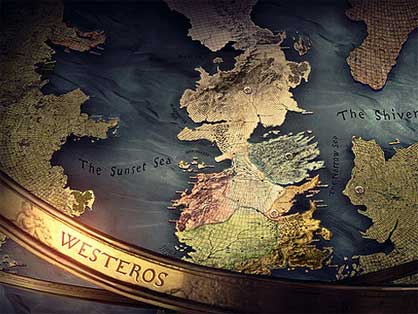
In the long and steamy affair between fantasy and cartography, certainly the most mesmerising image of recent vintage is the dynamic beauty kissed alive by the title sequence of Game of Thrones.
At the start of each episode, the viewer is strapped to a rollercoaster and swept across its alternate world.
The camera dips and climbs vertiginously over a map of fictional lands and their unfamiliar shores, halting at crucial spots for cities, castles and magical trees to shoot up from the earth, self-assembling like 22nd-century Ikea furniture.
Apart from enthralling map nuts, the opening sequence also sets the scene for the action to follow, using the map as an elaborate chessboard in mid-game and the castles its precariously positioned pieces.
The zoomed-in views occasionally reveal more than location and situation: the charred husk of a fortress serves as a brief memento of its sacking. We’re not just reading a map, we’re playing spy satellite.
Pinning down an imagined world with precise geography is nothing new: The map’s central position in fantasy literature stretches all the way back to Plato’s “Atlantis.”
In his 360 B.C. “Dialogues,” he situates the vanished island at “a distant point in the [Atlantic] Ocean” and describes it as “larger than Libya and Asia together,” housing “a confederation of kings, of great and marvellous power.” (Sounds a bit like Westeros).
These and more detailed geographic descriptions are meant to lend credence to Plato’s story – a discussion of the perfect society – though it’s unknown whether he thought he was recounting a true story with a moral, or knew he was concocting pure allegory.
Fantasy islands as a literary device became popular early in the Age of Exploration, when reports were coming in from far and wide of newly discovered lands.
In 1516, Thomas More placed his “Utopia” off the coast of Brazil, then recently visited by Amerigo Vespucci. As for its exact location, More said “someone coughed” when its exact longitude and latitude were related at court. But he specifies that the island is 200 miles across, and crescent-shaped; that it was a peninsula, until its king had a channel dug to separate it from the mainland; and that it contains 54 cities, each divided in four equal quarters.
A map printed with “Utopia’s” first edition shows the island to be vaguely skull-shaped. (These tales of Atlantis and other fantastical empires have a pendant in Essos, the other continent in “Game of Thrones”; it too once housed a great civilisation, its former seat of power said to be haunted by demons.)
Distant fictional lands as settings for social satire and morality tales would remain a literary trope throughout the centuries that followed – think of Gulliver’s travels to the fantastical island of Lilliput; or the Island of Despair, where the fictional Robinson Cruso